While Chris hiked, I got to know several of the hikers who crossed his path on the trail or in towns. I gave rides to and from the trail, had lunch and dinner with hikers, and sometimes camped with them or shared hotel rooms when they were ready for a break from the daily grind of hiking. I tried to interview a few of them to find out why they had carved out 5-6 months of their life in order to come live in nature and hike 2,660 miles.
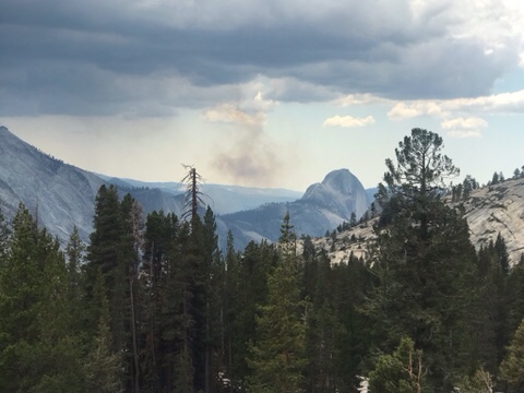
“The mountains are calling and I must go”, John Muir wrote in a letter to his sister in 1873, and after being in the Sierra Nevada mountains for the last few weeks, I can understand how he felt.
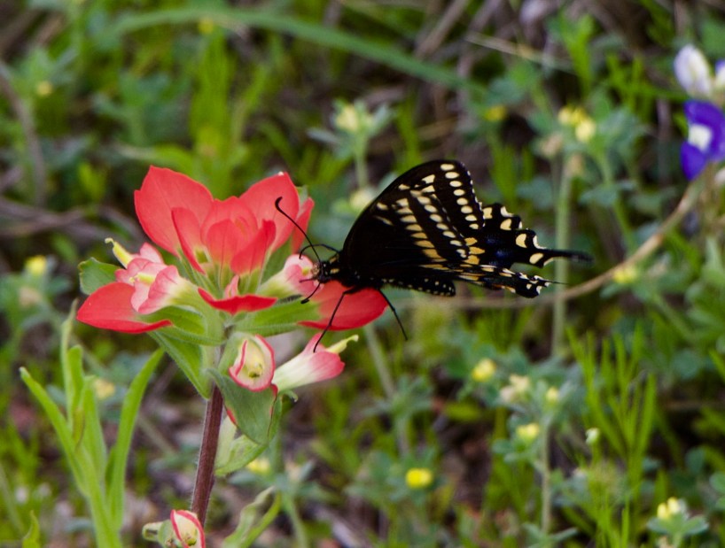
Although some of the toughest hiking, the Sierra Nevadas are also some of the most scenic
By mid-June, Chris and his hiking bubble had completed 25% of the trail, ending the “desert” portion of the trail. Starting June 14, he hiked out of Kennedy Meadows South, and began traversing the southern Sierra mountains. This part of the trail included the longest stretch of the trail with no access to resupply points, and no cell coverage. I camped with him at Cottonwood Meadow Campground, up in the Alabama Hills just west of Death Valley and the little town of Lone Pine on 395, and brought him a giant Subway sandwich and enough dry foods for eight days of hiking. Which makes a really heavy pack! When he left the next morning, he began the trek to get to the top of Mount Whitney, the tallest mountain in the continental US.
We had a four day weekend off of work this month, so Chris and I decided to spend a little time at the beach. We packed up our car and drove down to South Padre Island down in the Rio Grande Valley of south Texas. Now, the last time I was in SPI was 1997 and it was college spring break week- and I was there to see Vanilla Ice in concert. So I was interested to see how the island had changed over the last 20+ years.
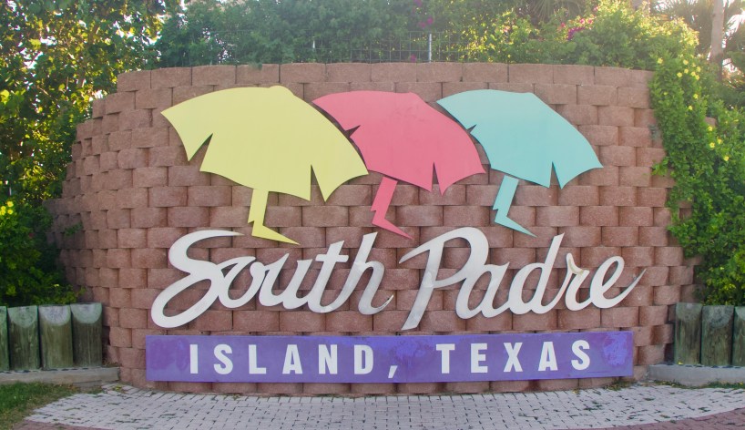
South Padre Island, Texas
There is exactly one way to get onto South Padre Island, and that is via the Queen Isabella Causeway, from Port Isabel. You cannot enter the island from a more northern point, so just know that if you want to visit, you will need to go alllllllll the way down to the bottom of Texas to get there. From Austin, it took us about six hours. We arrived in time to grab an early dinner at Dirty Al’s, a Cajun-style seafood joint directly on the water. You can eat indoors or outside, and enjoy the Gulf breeze while watching the sailboats come in and out of the harbor. You can also book an island tour, sportfishing boat, or dolphin-spotting cruise from some of the businesses just steps away.
SPI Harbor
The entire south end of the island is Isla Blanca Park, run by Cameron County. To access those parts, you’ll need to pay a $12 day pass, or $5 for Veterans (you can also get a monthly or annual pass). Some of the cleanest beaches and best sunset-watching spots are down in Isla Blanca Park, as well as RV spots, cabanas, and a huge statue of “Cristo de los Pescadores”. But don’t worry. South Padre Island has plenty of free beaches in the mid-island and northern island sections.
Sunset at the Queen Isabella Causeway
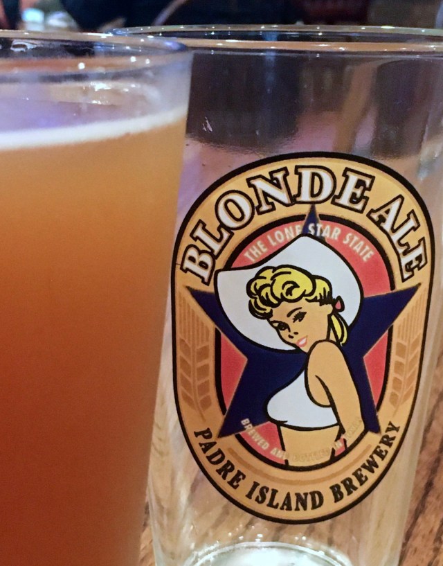
There’s always fresh, cold beer on tap at the Padre Island Brewing Company
For eating, drinking, and partying, most people head mid-island to Clayton’s, Bar Louie, and The Lookout. These 3 open-air bars are always full, with food and drink specials, music, and plenty of sandy feet. At night there’s usually a DJ or a band playing at one or more of these venues. For a more mellow vibe, try a local brew at the PI Brewing Company.
But South Padre Island has plenty to do for nature lovers as well. You can visit Sea Turtle Inc, or the SPI Birding and Nature Center. A bit further north from town, there’s the Stables, the SPI Equestrian and Events Centre. You can ride horses and zipline at the South Padre Island adventure park, or visit the Kite Boarding Ranch. If all of these sound too adventurous to you, just go to the end of State Road 100, and visit the beautiful white sand dunes and less-visited beaches in the north of the island.
The surge was high this weekend due to Hurricane Delta!
While we were on SPI, a hurricane was affecting the tides throughout the Gulf of Mexico, so we took some time inland to explore a little as well. Just south of SPI you can visit the SpaceX launch site. Be warned: although only 6 or 7 miles south of SPI, it takes a while to get there- you’ll need to drive inland about 25 minutes, and then double back on another road to get to the space center (it’s just before Boca Chica State Park).
SpaceX Launch Site
And if you’re wondering- can you walk across the border to Mexico? The answer is yes. There are 3 international bridges located in Brownsville, Texas, linking to Matamoros, Mexico. We walked across the Gateway International Bridge with our passports and $1 in quarter for the toll. On the Mexican side, you can hop on a bus to pretty much anywhere in Mexico (prepare for some long rides), or just have a cerveza and some lunch, shop a little, and head on back. Just a block or two over the border is a large shop and restaurant called Garcia’s- they have great food and specials on Mexican products and liquors. They took our temperature before we entered and sanitized our hands. The line back into the US took a bit longer than the one heading south- prepare for a bit of a wait- but it only costs 25 cents. Not bad for an international trip!
Last week we visited Galveston Island for a couple of days, followed by a weekend in Houston. Whether you’re there for a week or just a few days, both cities have lots of fun and off-the-beaten-path things to do that won’t break your budget! Whether you’re a NASA fan or love lying on the beach, this area has you covered.
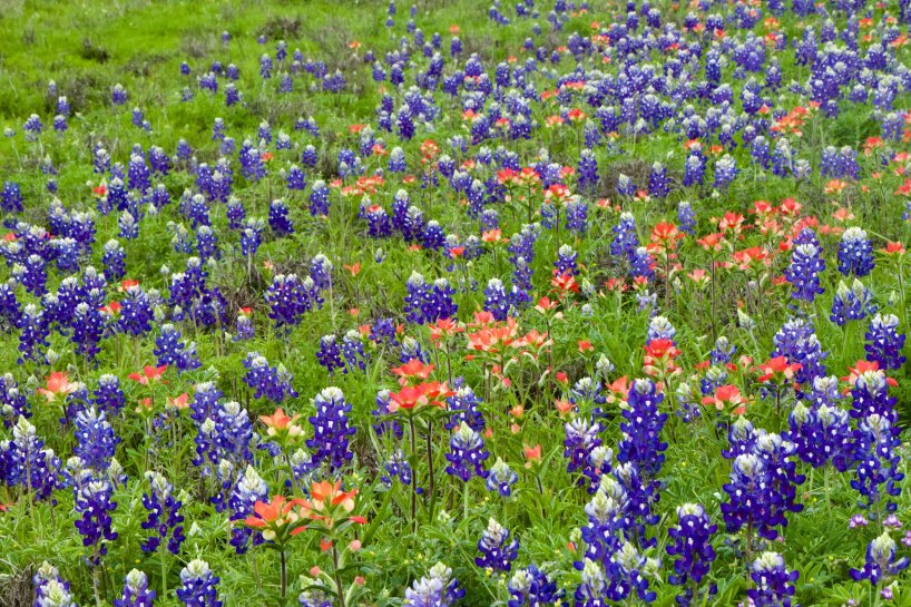
I am originally from Texas, but moved away in 2003. Last year we returned to live in Texas, so we decided to go to Big Bend National Park over my Spring Break. With some reports of the Covid-19 contagion coming in, we decided to pack our own food for the trip and to camp, so as to be able to isolate ourselves as much as possible. We left the Austin area and drove across the beautiful central hill country, where the sides of the highways and byways are carpeted with bluebonnets during the month of March.
Ever since Lady Bird Johnson was First Lady, the Texas Department of Transportation has sown more than 30,000 pounds of bluebonnet seeds around the state annually.
Before entering Big Bend, we took a spin around the town of Marfa, a place I had heard of (due to the mysterious “Marfa lights” and also from their reputation as a Bohemian artists’ colony). I wish we could have stayed in town and eaten there, but we were already heeding warnings to not bring any outside germs into small rural communities so we just did a pass through.
With a population of only 1800, you stand a good chance of exploring all of Marfa in a long weekend. Keep an eye out for celebs like Matthew McConaughey
We spent the first day at Big Bend driving the scenic Maxwell Drive, which is essentially the west half of the park. We headed all the way to the Mexican border, where we hiked into the Santa Elena Canyon, fording an off-shoot of the Rio Grande River. The area was busy with hikers and kayakers, but people were staying a fair distance apart. The amazing effects of the eroding power of water were on full display in the canyon, with 1500 foot towering cliffs on either side of us.
Santa Elena Canyon
Chris hiking up the Santa Elena Canyon
Deah fording an offshoot of the Rio Grande to get to the Santa Elena Canyon viewpoint
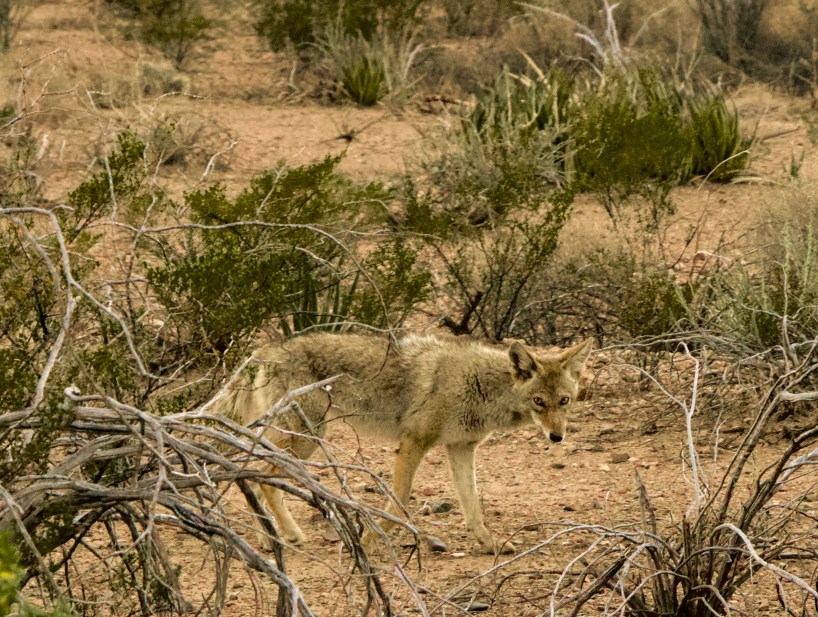
Later, we drove the Chisos Basin drive. It was approaching sunset and there were some beautiful views. On the way out of that area, we spotted a coyote and were able to snap a pic. We also spotted some golden eagles flying around and Chris got a nice shot of those.
Spotting the wildlife around the park
A Golden Eagle
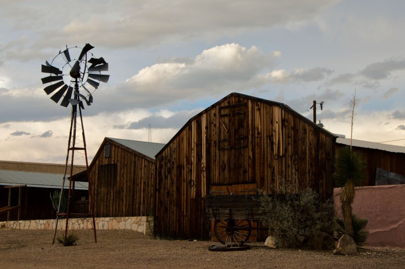
We camped near the ghost town of Terlingua. There are a number of cabin rentals, small hotels, bars, and restaurants there. Of course, they are most famous for their annual chili cook off in November. We had our own dinner to cook at our campsite so we just took a drive through town to see the dusty sights.
Terlingua: population 2,000 but this small town swells to over 10,000 annually with the chili cookoff
High on a hill overlooking the road into Terlingua
The next day we explored the eastern half of Big Bend. We made up a breakfast at the picnic tables at Dugout Wells. There we encountered a woman waiting for a scheduled ranger talk, but soon found out that the visitor’s center had been closed and all ranger talks and guided walks were canceled for the time being (campgrounds still open for the week). We continued our drive all the way to the eastern end of the park, to the Rio Grande Village, and hiked a bit into the Boquillas Canyon. Along the way, we saw small homemade souvenir “caches” of trinkets made by residents of the village of Boquilla, Mexico (you can leave the money in a jar and they come collect it later). We were serenaded across the border river by a man with a wonderful singing voice, his song echoing across the canyon. In normal operating times, if you bring your passport (kids just need a birth certificate or proof of citizenship) you can cross the river at Boquillas Crossing ($5 rowboat round trip) and have lunch and explore the small Mexican village. However, the crossing was closed this week.
A small souvenir stand
Recent rains had the cacti in full bloom while we were there
Along the southeastern edge of the park, we were able to hike to and enjoy a hot springs. Many years ago there were actually cotton plantations in this area, with dozens of workers and a somewhat-thriving industry. In fact, in the 1860s they even imported 30 camels and their handlers from North Africa to use to explore and patrol the area!
A hot springs built on the sides of the Rio Grande River
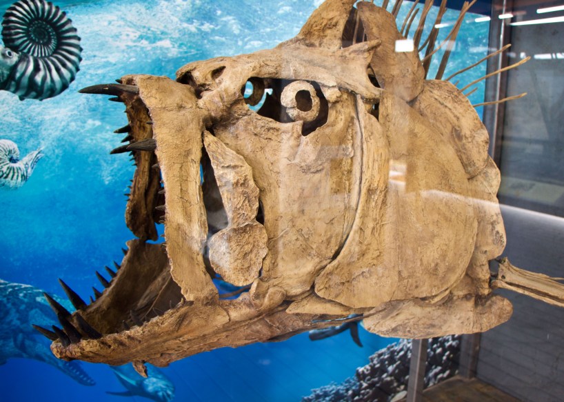
With more and more dire news coming in every time we stopped to check messages, we decided to cut our trip short and head home. We made one final stop on our way out of the park at the Fossil Discovery Exhibit (built in 2017), where some of the largest fossil finds in the US have occurred. Over 1200 fossils spanning 130 million years of geohistory have been found there. You can see a replica of some of the largest dinosaurs that ever existed, such as the Tyrannosaurus Rex, the Deinosuchus (an alligatoroid bigger than a school bus!), and the Quetzalcoatlus northropi (the largest flying creature). Fossil finds from all three giants have been found in the park’s perimeter.
Xiphactinus, a giant spiny fish from the Late Cretaceous Era
We exited the park via the Persimmon Gap entrance, and spent one more night in the area, and drove home the next day. The bluebonnets, Indian paintbrushes, and other wildflowers were a welcome sight to us as we headed home to make a decision about Chris’s Pacific Crest Trail hike plans.