
“The mountains are calling and I must go”, John Muir wrote in a letter to his sister in 1873, and after being in the Sierra Nevada mountains for the last few weeks, I can understand how he felt.
By mid-June, Chris and his hiking bubble had completed 25% of the trail, ending the “desert” portion of the trail. Starting June 14, he hiked out of Kennedy Meadows South, and began traversing the southern Sierra mountains. This part of the trail included the longest stretch of the trail with no access to resupply points, and no cell coverage. I camped with him at Cottonwood Meadow Campground, up in the Alabama Hills just west of Death Valley and the little town of Lone Pine on 395, and brought him a giant Subway sandwich and enough dry foods for eight days of hiking. Which makes a really heavy pack! When he left the next morning, he began the trek to get to the top of Mount Whitney, the tallest mountain in the continental US.

As PCT permit holders are allowed to hike Mt Whitney but not camp there, he had to do the 8-mile side trail to the top, and return to the PCT, all in one day. From there, he headed up to Forester Pass, the highest point of the PCT, at 13, 153 feet. Meanwhile, I stayed at various campgrounds and hostels along 395, visiting the outskirts of Death Valley, the Manzanar Internment Camp, and small towns such as Lone Pine, Independence, and Bishop. While Chris was heading over the Sierra Nevada ridges, there was a fire near the Whitney Portal, so a lot of people who had planned to hike up to Mt Whitney (they have to get tickets by lottery months in advance) were not able to do so. I shuttled a few hikers up to different points along the ridgeline that had access to the trails to get around the closure.
Some of our hiker friends chose to come down off the trail at Kearsarge Pass, rather than do an 8-day food carry, so I shuttled some hikers from Kearsarge to Bishop and to Mammoth Lakes for some rest, relaxation, and resupply. Somewhat of a hiker vortex, I wound up spending over a week in Mammoth, having a great time! I saw a movie (Fast Nine), visited friends who live in the area, ate at the same restaurant as the singer Pink and her family, had a girls’ night at the Westin, and volunteered with a trail maintenance group. I rode the free trolleys all around Mammoth, and at last I got a text from Chris to go pick him up at Red’s Meadow. He was through the longest stretch and ready for a break. Together we hiked to Rainbow Falls and Devil’s Postpile, a national monument, and then got off trail for a couple of days.

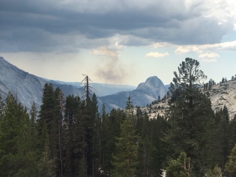
From Mammoth Lakes, Chris headed through Yosemite National Park on the PCT, while I stayed in town two more days, then I camped in Yosemite National Park with our friends Tricia and Kirk. You have to apply for camping passes pretty far in advance for Yosemite this summer, so our dates didn’t quite work out for them to see Chris as he hiked through, so Tricia and Kirk had to make do with me. It rained- and even hailed- the weekend we camped, but the next day the weather was warm and sunny as I drove down to to the valley floor and explored the park. What a beautiful national park! It is easy to see why John Muir and other naturalists fought so hard to have it designated as a protected space.

After Yosemite, Chris headed northwest towards Kennedy Meadows North, and I continued up 395 to towns such as Ridgecrest, Walker, and Topaz Lake. Since I had a few days to kill, I used the Facebook PCT Trail Angel page to help a few hikers who needed to get on or off the trail in the Antelope Valley/Sonora Pass area. I was in Walker just a few days before a 5.9 earthquake closed the road. Although I did see some hail while I was there, and Chris messaged that he had lightning and hail where he was camped, neither of us were detoured by the weather.

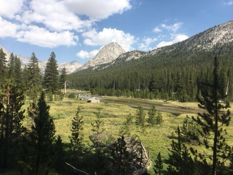
I was in South Lake Tahoe for July 4th, and Chris rolled in the next morning. The holiday was a fairly quiet one this year, as Tahoe did not have their famous “Lights on the Lake” fireworks show, due to Covid. However, the natural beauty of the area was still there, and as I drove around the western edge of the lake and camped at Emerald Bay, and then up at Barker Pass, I was amazed at how pretty Lake Tahoe and Tahoe National Forest are.

We were able to regroup in the Truckee area- we camped at a campground near the Truckee River, and got to swim and tube down the river. A friend of ours from Burning Man who lives in Sacramento made the drive up to Truckee to have dinner with us, and it was great to catch up with Miss Margot. We took a zero day in Reno and did some resupplying and of course had a giant breakfast of steak and eggs at one of the casinos.

As Chris headed north through the Tahoe National Forest and then the Plumas National Forest, I took a few days to head over to Napa River Valley, where my college roommate and I had a nice weekend together. Nicole and I explored the small town of Napa, and took the wine trolley to visit a few wineries and taste their wines. It was a nice weekend and a good break from all the hikers! The Napa River Inn has a lovely view of the river and the town, as well as a great bakery.

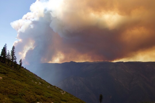
I was able to rejoin Chris just in time to get to the halfway point of the PCT, which is between the tiny town of Beldan, and the slightly larger town of Chester. Already too lean, Chris literally had gotten thinner in the five days I was gone. Although Chris was able to hike into Beldan without any problems, the trail was closed by the Plumas County Sheriff and the firefighters, who were battling more than one fire in the area. I picked him and several other hikers up by car, and together we all shuttled around the 45 mile closure, to regroup in Chester. So now we are officially at the halfway point of the PCT- mile 1325- but as they say, the second half of the PCT is always shorter than the first half, due to fires. From here on out we anticipate a lot of closures between northern California, Oregon, and Washington.
If you’re interested in reading about the next stretch of the PCT, be sure to click “follow” below.

One thought on “Chris Hikes the PCT- part 2: the Sierra Nevada”