While Chris hiked, I got to know several of the hikers who crossed his path on the trail or in towns. I gave rides to and from the trail, had lunch and dinner with hikers, and sometimes camped with them or shared hotel rooms when they were ready for a break from the daily grind of hiking. I tried to interview a few of them to find out why they had carved out 5-6 months of their life in order to come live in nature and hike 2,660 miles.
“The mountains are calling and I must go”, John Muir wrote in a letter to his sister in 1873, and after being in the Sierra Nevada mountains for the last few weeks, I can understand how he felt.
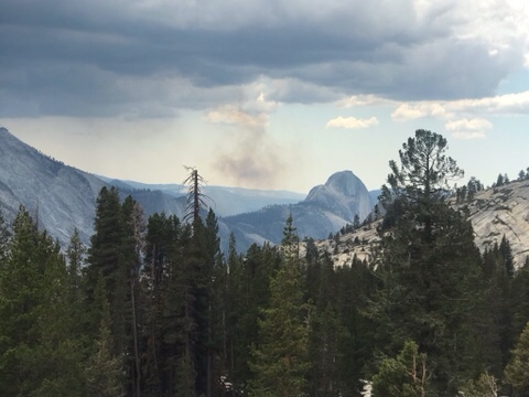
Although some of the toughest hiking, the Sierra Nevadas are also some of the most scenic
By mid-June, Chris and his hiking bubble had completed 25% of the trail, ending the “desert” portion of the trail. Starting June 14, he hiked out of Kennedy Meadows South, and began traversing the southern Sierra mountains. This part of the trail included the longest stretch of the trail with no access to resupply points, and no cell coverage. I camped with him at Cottonwood Meadow Campground, up in the Alabama Hills just west of Death Valley and the little town of Lone Pine on 395, and brought him a giant Subway sandwich and enough dry foods for eight days of hiking. Which makes a really heavy pack! When he left the next morning, he began the trek to get to the top of Mount Whitney, the tallest mountain in the continental US.
Chris set off in late April to hike the Pacific Crest Trail, hopefully in its entirety (2,650 miles). Visiting some friends and family along the way, he was able to leave our car with our friend Touch in San Diego, and arrived at the start of the PCT on the night of May 3rd. Months before, he had applied for a PCT permit, and had a start date of May 4 at Campo, on the California/Mexico border.
Chris at the start of the PCT
The PCT starts off hot and sandy, with moderate hills and few water sources in low-rainfall years. Chris hiked his way past small towns such as Julian, Warner Springs, and Idyllwild, and up and then down mountains such as Mt. San Jacinto (10,883 feet). Taking a long weekend, I flew to San Diego, picked up our car, and drove to the point where the PCT meets I-10 near Palm Springs. Thanks to the Garmin InReach GPS/SOS Chris’s parents bought for the hike, we actually timed it really well, and Chris arrived at our rendezvous only 15 minutes after I did. Having just hiked 20 miles down a mountain ridge, in an extremely windy area (known for its wind farms), he was happy to take a “zero” and a “near-o” to spend some time together, resupply his food pack, and rest his feet. We also visited Joshua Tree National Park (although, he was not interested in hiking any trails there… I wonder why).